For the past couple of years, Havasupai has been one of the most sought after destinations due to its natural blue green waters and paradise-like vibes. What many don’t know is that the booking process is quite exclusive, and the research and preparation for this backpacking trip also plays a huge part in the trip’s success.
Through this post, I’ll cover all that you need to know before you get online to snag reservations. Havasupai was definitely a unique experience— it totally brought stunning views of beautiful turquoise waterfalls, an unforgettable adventure, and a peek into the Supai native’s lives. I’d say that as gorgeous as all the views were, the entire trip included a roller coaster ride of emotions!
Here we’ll cover:
- The best time of year to go
- Permits
- Packing list
- The hike and transportation options
- The village
- The waterfalls and day-hikes
Photos by me and Jetty
Best Time of Year to Go
Whenever you see photos of Havasu, it looks like it's always sunny, warm, with appearance of prime swim suit weather. The common assumption is that the best time to visit Havasu is during summer-time, but this is not the case. I’d say the best time would probably be Spring (April - June).
Why not Summer?
In the summer, although the water is warm and would probably be the most ideal to swim in, there is a higher risk for flash-floods due to the fact that it would be the South West’s monsoon season, which is around July to early September. If you’re spending around $200 per reservation and plane tickets, it’s up to you to weigh the risk. I’m not saying the whole entire summer will have flash floods and storms, but rainfall is higher during this season. When there is rain in the canyon, it’s likely to flood quickly, and can be quite dangerous.
There were several times in the year where the tourism office had to evacuate visitors out with helicopters and ATVs.
See this handy rain chart here.
Why Spring?
As you can see in the rain chart, Spring has the least rainfall, followed by Winter and Fall. Temperatures will also be milder, and not as extreme versus Summer and Winter.
Also, since the gorgeous blue-green color of the water comes from minerals of the Havasu Creek and Colorado River, the best condition is when there is less rainfall, so that the rain will not dilute the minerals (high levels of dissolved magnesium and calcium). Here, you’ll likely see the bluest of waters compared to all other parts of the year.
Permits
Applications for permits launch on February 1 at 8AM MST. Their application process used to be only over the phone (which used to be a HUGE pain since we’d try and call like 300 times); however, you may now conveniently use their online application service to book.
Do keep in mind that the reservations run out super quickly on the day it opens, so a couple of tips when you’re thinking about this trip is to plan with your group in advance and:
- Know who and how many people you’re going with
- Know who is going to pay ($200+ per head, so be prepared to front a lot of money)
- Which dates you will be free, and I say DATES because even if you’re on their site at 8AM MST, it may be likely that your desired dates will have already been booked. Also, be prepared to sacrifice weekdays
When I was booking, I had a rough headcount of people who were certain, and a bit uncertain. I took a risk and bought more reservations than my confirmed headcount, and guessed everyone’s availability. It was stressful, but I’m thankful that my friends were flexible and willing to sacrifice week days to join in on this once-in-a-lifetime opportunity.
When you finish booking, you’ll receive an email confirmation with your reservation number. Be sure to flag this email as important, as you will need a screenshot on your phone or the printed reservation info when you hike in. Do note that you may NOT simply walk-in to camp or do a day hike since the rangers there will check your reservation will you're hiking.
Packing
Note that this is a 10 mile hike in, and a 10 mile hike out (uphill). You’d want to be as minimalistic as possible. But if you cannot, you’ll have options to have their mules take your bags in (~$132 USD for a mule, $33 per bag if you split it with a group). You may get a mule during certain hours at their front office at the trailhead, or when you’re at the tourism office inside the reservation.
Our group brought in our bags and backpacked the whole 10 mile in. After realizing how broken our bodies were when we got to the tourism office, we got mule service for the hike out. It was worth it, especially since this was most of the group’s first backpacking trip.
Here’s a quick packing list of what you might need, since you’re essentially camping for the next couple of days you’re inside:
- A sturdy and FITTING Backpack: Please get fitted at REI and don’t make the same mistake I made. I got a large women’s backpack when I’m a small. The hike in was a bit uncomfortable.
- Jet Boil or small stove to cook your food
- MRE or dry-food— these were super convenient and delicious depending on what you get. I typically like to get Mountain House foods. Simply add water, and you have yourself a 1-2 person meal
- Snacks for the hike
- Water Filtration system: Can’t stress enough how important this is. You cannot drink the water at the falls or lakes because they have certain minerals and viruses that you cannot consume. The campsites also have a spring water source; however, I highly recommend filtering that water just in case. A filter I brought with me was the portable Sawyer filter— super straightforward and easy to use
- Foldable Water Jug— this will be important when you’re getting water to filter for your campsite
- Portable Lantern for the night time
- Head lamps (super handy when I had to wander to the bathroom at night)
- Hiking poles: Helps with support while hiking
- Good hiking boots
- Water Sandals: This was the best purchase for this trip. You’ll hike through rivers during the day hikes while you’re there
- Swim Suit / Trunks
- Warm sleeping bag for the season
- SUNBLOCK SUNBLOCK SUNBLOCK
- Body wipes - I mean, they have toilet paper in their bathrooms, but sometimes they run out. You don’t wanna be stuck in a situation where there’s no TP!
- Layers for clothing - It can be warm during the day, but very cold at night
- Poncho for if it starts pouring
Overall, just make sure your backpack and everything in it fits comfortably before you hike. Adjust the straps and how it sits, so that you may enjoy the hike :)
The Hike
The hike itself is about a 3,000+ ft elevation change, and is characterized as strenuous on AllTrails. Most waterfall hikes include a descent on the way in, and an ascent on the way out. At first, our group was intimidated by how steep it will be, especially since we were backpacking it. But the steep and most difficult part is really the first mile since it’s full of switchbacks as you descend into the canyon, and then the elevation change becomes gradual.
Photo by Warren Photo by Bryant
Because the elevation change is gnarly in the very beginning and end, I highly recommend bringing hiking poles to support the weight you’d have to lug in and out of the canyon. This is even helpful during the gradual changes of elevation in between because it’ll support you and your heavy pack through the entire hike.
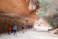
Although long, the hike itself is quite beautiful. You’ll witness the flash-flood carved canyons and all of the striations that were left on the sides of the rocks. You’ll find lots of desert plants including small bushes and cacti. The hike in reminds me a bit of any of the Grand Canyon or Zion National Park hikes— tall canyon walls with carved out “subways.” This is why if there were a flash flood in the valley, it’d be dangerous to be hiking in it. We hiked in post-storm due to Hurricane Rosa, and some of the tourists who stayed at the parking lot overnight warned us to wait for the rain to die down before heading in.
If you want to take a chopper out
Some people might also wonder if options to take a helicopter would be doable-- the answer is yes. You may heli in and out only on certain days-- please check this out. You may heli into the canyon only on Monday, Thursday, Friday and Sunday. We didn't have the option to fly out, but the hike out wasn't too bad with our packs less heavy since we consumed most of our food.


Photos by Bryant
First Small Stop
Once you are about 8 miles in, you’ll start seeing signs for the village of Supai. The first small stop you get to is not going to be the actual village where you’ll check in— it’ll be a small stop for you to buy snacks or try Supai’s infamous fry bread. Feel free to skip this if you don’t need to stop, because the actual village, which is about 0.5 miles further down, is where you’ll check in to get your wristbands and camping permits at the tourism office. Also note that there is a cafe in the village, so if you’re going to prioritize one stop over the other, I’d consider skipping the first small village to maximize on time (gotta pick and prioritize getting the ideal campsite first!)
The Village itself
When you get to the tourism office, don’t bother waiting in line. Grab the form at the front desk, and start filling it out, because you’ll need a complete form with information filled out on your group and belongings before you can get the permits. You may also pay for a mule on your way out here— it’s about $132 for a mule, which is equivalent to 4 bags. If you’re traveling with a group, you can get one mule and split it amongst 4 people ($33 / bag).
As beautiful and paradise-like Havasupai may seem, I’d say that the village was quite underwhelming. The reservation and its location doesn’t allow other forms of transportation except for horses or helicopters, so resources are very limited, and trash can pile up. It was very sad to see the squalid conditions that the natives live in, and it was also uncomfortable for us to see the lack of nutrition in the meals that the villagers get, especially since they only have one cafe and one general store in the area. One thing I did brace myself for is all of the TripAdvisor reviews about starved horses and mules. I didn’t see extreme conditions like that, but I can imagine the difficulty of the living standards in Supai. Because of this, I was more motivated to pack out my trash when I can, and did my best to leave our campsite better than when we found it.
Photo by Warren
Campsites
About 0.2 miles further from Havasu Falls, you’ll see an entrance to the campsite. You’ll be greeted with fenced gate and the first bathroom. This is also the spot where you’ll drop off your bags in the morning of if you’re getting a mule for your bags on the way back (majority of our group did this since our group had a flight to catch, and hiking without our bags would allow us to power through faster).
Choosing a site for your group
There are several things to consider when you’re choosing your campsite for the next couple of days you’re here. This is why I recommended getting to the campsites as early as you can— other backpackers will trickle in throughout the day, and there are only limited amount of sites here. Getting here early will allow you to get decent picks on where to lay your head for the next few days.
Proximity to the flowing Spring Water
Yes, there’s drinking water in the campsite! But there’s only one spring water spout in the campsite, and if your group will be using a lot of water for hydration, cooking, and other daily usages, it’d be much more convenient to stay closer to the spring.
Although the Spring is labeled as "safe to drink," I'd still filter it to be safe. There are plenty of options you can explore for water filtration. Lifestraw, portable filters, and iodine pills were what our group used.
Watch for Flooding
Also, keep in mind that it does rain in Havasupai, and even when it’s raining lightly, water levels can rise quickly within the canyon. If you’re going during a week that is raining, or is going through post-storm conditions, be mindful and camp on higher ground so that your campsite will not get flooded.
On your way to the campsites, you’ll stop through a series of waterfalls— the main reason why you’re here in the first place!
Navajo Falls
About 0.4 miles from the village, you’ll arrive at Navajo Falls. My regret was not spending time here, since we weren’t able to squeeze it in this visit. But let’s just take some time to appreciate this gorgeous canyon and layered waterfall.
Photo by me
Havasu Falls
Once you hike further down about half a mile towards Havasu Falls, you’ll arrive at the Falls first before descending down to the campsites. As you descend, don’t forget to peer over your right, since you’ll get a breathtaking view of Havasu Falls. This is a great photo opportunity to get a shot above the falls, as you’ll find an iconic shot of what makes Havasupai so famous.
If you’re trying to go to the base of Havasu Falls, there’s a small trail you can access— this will be pretty straightforward to find because there are wooden signs that will guide you.

 Photos by me and Jetty
Day Hikes
Mooney Falls
The most iconic day-hike of all of Havasupai is Mooney Falls. It's a tall waterfall-- taller than Niagra Falls, and is famous for its majestic flow against the red and brown back drop.
The hike down is a bit treacherous-- if you're afraid of heights, this may be intense for you. Several visitors and even several of my friends were dreading this journey down, while my climbing and bouldering friends were super excited about this descent. Be careful, because the waterfall sprays makes the climb down slippery.
Photos by Bryant and Warren
Aaaaanndd this is where Jetty proposed to me 💕
Photos by Warren
Beaver Falls
The journey to Beaver falls is about 1.5 miles further down, and it's one of the most beautiful hikes in Supai. You'll encounter about 3 river crossings, a lush "jungle" that will take you to The Land Before Time, and a fun descent down to several layered waterfalls. Do note that there are about 2 smaller-looking Beaver Falls that won't actually be Beaver Falls. You'll know that you've arrived at Beaver Falls when you see the wooden sign after a steep descent.
Photo by Me
And here's the majestic Beaver Falls! I would say that even though the round trip hike from Mooney to Beaver Falls is 3 miles total, I believe that Beaver falls is worth it because it was so nice to play on the shallow plateau of the layered waterfalls with our group. It was absolutely gorgeous.
Colorado River Confluence
Our group didn't get to do the hike down to the Colorado River Confluence, but this is something we certainly will come back for. It's about a 5-6 mile hike from Beaver Falls. This Blog from Blonde Coyote has a good visual of what it looks like.
Ending our Trip
During the past 3 days of camping in Havasupai, our trip was filled with ups and downs due to weather inconsistency. But our group was rather cheerful and hopeful, and that was what made the trip SO worthwhile. Our camp of 13 people ended up hiking out starting at 4:30 AM and finishing the ascent back up to the Hualapai Hilltop at 10:00 AM. On the hilltop, we had a cooler of ice-cold beers and a stash of junk food that awaited our arrival. It was the best ending anyone can ever ask for :)
Please feel free to leave a comment regarding questions about this post!
Resources


